Nandadevi National Park
Nandadevi National Park
Park At A Glance
| IUCN Category | II (National park) I (Strict Nature Reserve) X (World Heritage Site) |
| State | Uttaranchal |
| District | Chamoli |
| Area | 630 Sq. km. |
| Year of Notification | 6th November 1982 |
| Special Status | Biosphere Reserve |
| Altitude | 2.100m-7,817m |
| Latitude | 30o 16’-30o 32’ N |
| Longitude | 79o 44’-80o 02’ E |
| Altitude | 2100m-3,500m. |
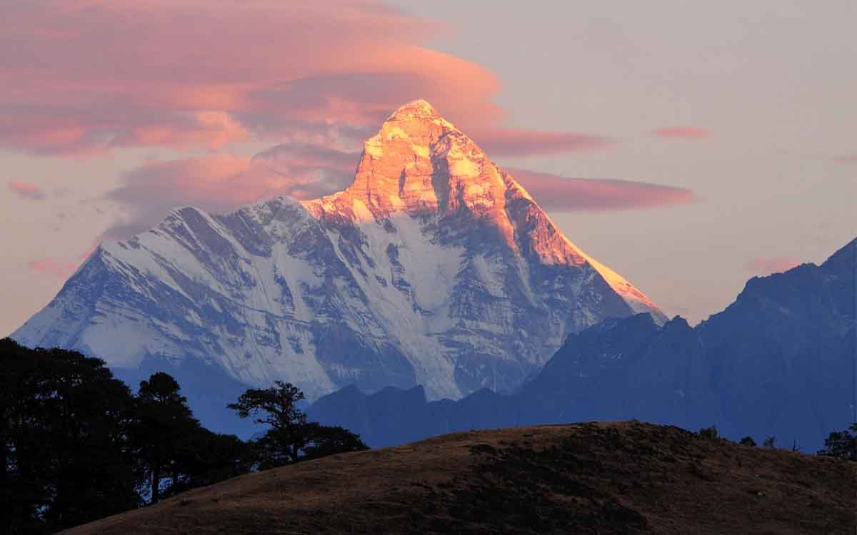
| Nanda Devi | West at 7,817m is the hihgestpeak. |
| Period for Visit | April-October |
| Nearest Town | Joshimath (23 Km) |
| Nearest Railway Station | Rishikesh (276 km) |
| Nearest Airport | Dehradun (295 Km) |
Nanda Devi National Park lies in Chamoli district, within the Garhwal Himalayas of Uttaranchal state. The main entry point to the park is via Lata village, some 25 km from Joshimath. The park is bounded by high mountain ridges and peaks on all sides except its western side, which features a deep and virtually inaccessible gorge. 30°16′-30°32’N, 79°44′-80°02’E. The Nanda Devi National Park is categorized as a “strict nature reserve” by IUCN. This basin of spectacular mountain wilderness was established as a game sanctuary in 1939. It was notified as a national park in 1982. The park was inscribed on the World Heritage List in 1988. The park spread over an area of 70,000 ha, constitutes the core of a Biosphere with a much larger area (200,000 ha), extending as far north as the Dhauli Ganga.
The entire basin is above 3,500m, apart from the lower Rishi Gorge which descends to 2,100m. Nanda Devi West at 7,817m is the highest peak.
Comprises the catchment area of the Rishi Ganga, an eastern tributary of Dhauli Ganga which flows into the Alaknanda River at Joshimath. The area is a vast glacial basin, divided by a series of parallel, north-south oriented ridges. These rise up to the encircling mountain rim along which are about a dozen peaks above 6,400 m, the better known including Dunagiri (7,066m), Changbang (6,864m) and Nanda Devi East (7,434m). Nanda Devi West, India’s second highest mountain, lies on a short ridge projecting into the basin and rises up from Nanda Devi East on the eastern rim. Trisul (7,120m), in the south-west, also lies inside the basin. The upper Rishi Valley, often referred to as the ‘Inner Sanctuary’, is fed by Changbang, North Rishi and North Nanda Devi glaciers to the north and by South Nanda Devi and South Rishi glaciers to the south of the Nanda Devi massif. There is an impressive gorge cutting through the Devistan-Rishikot ridge below the confluence of the North and South Rishi rivers. The Trisuli and Ramani glaciers are features of the lower Rishi Valley or ‘Outer Sanctuary’, below which the Rishi Ganga enters the narrow, steep-sided lower gorge. The greater part of
the park falls within the Central Crystallines, a zone of young granites and metamorphic rocks. Along the northern edge is exposed the Tibetan-Tethys, consisting of sediments of sandstones, micaceous quartzite, limestones and shales. The Tethys sediments form Nanda Devi itself and many of the surrounding peaks, and display spectacular folding and thrusting, while mountains like Changbang are granite. The crystalline rocks of the Vaikrita Group and lower part of the Tethys sediments have been tentatively subdivided into four formations, namely: Lata, Ramani, Kharapatal and Martoli.
Being an inner Himalayan valley, Nanda Devi Basin enjoys a distinctive microclimate. Conditions are generally dry with low annual precipitation, but there is heavy rainfall during the monsoon, from late June to August. Prevailing mist and low cloud during the monsoon keeps the soil moist, hence the lusher vegetation than is usually characteristic of drier inner Himalayan valleys. The basin is snow-bound for about six months of the year, snow being deeper and at lower altitudes on the southern side than the northern.